- Visitors
- Researchers
- Students
- Community
- Information for the tourist
- Hours and fees
- How to get?
- Visitor Regulations
- Virtual tours
- Classic route
- Mystical route
- Specialized route
- Site museum
- Know the town
- Cultural Spaces
- Cao Museum
- Huaca Cao Viejo
- Huaca Prieta
- Huaca Cortada
- Ceremonial Well
- Walls
- Play at home
- Puzzle
- Trivia
- Memorize
- Crosswords
- Alphabet soup
- Crafts
- Pac-Man Moche
- Workshops and Inventory
- Micro-workshops
- Collections inventory
- News
- Researchers
- The Chimú lordship and its presence in the Chicama Valley
News
CategoriesSelect the category you want to see:
Magdalena de Cao to Once Again Host an International Mural Art Gathering ...
Explore El Brujo Through Virtual Tours: Culture and History at a Click ...
To receive new news.
By: Jose Ismael Alva Ch.
By: Jose Ismael Alva Ch.
Resident Archaeologist at the El Brujo Archaeological Complex
“Some Indians say that in ancient times, before the Inca had lordships, there was in this valley a powerful lord, who was called Chimo, as the valley is named today. He did great things, winning many battles, and built some buildings that, even though they are so old, clearly appear to have been a great thing.” (Cieza de León 1984, p. 207)
Between the years 900 and 1470 CE, the Chimú lordship developed as one of the most emblematic and powerful societies of the North Coast of ancient Peru. Before its annexation by Tahuantinsuyu, the Chimú had begun and then consolidated an expansionist project that came to cover a wide territory from Piura to northern Lima, with Chan Chan as its capital city (Moore & Mackey 2008). During this process of imperial expansion, Chimú caused the construction of administrative centers and irrigations systems in the incorporated valleys.
The Chicama Valley
The Chicama is one of the most fertile valleys of the North Coast. This is due to the torrential cycle of its river, responsible for provided great volumes of water during the summer season; as well as for the investment of its labor force in the construction of canal systems, which contributed to redirecting those waters to amplify the cultivable areas from Cupisnique times through the Chimú era (Bazán 2022; Huckleberry et al. 2017).
The Chimú and the hydraulic resource of the Chicama
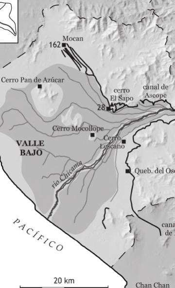
Around the 18th century CE, the Chimú entered the Chicama Valley and sought to take advantage of its river’s waters to strengthen agriculture on the plains of Mocan (on the right-hand shore of the Chicama), through the remodeling of the canal system of Ascope, originally constructed, as far as we know, during the Lambayeque Period (900-1200 CE) (Huckleberry et al. 2017; Watson 1979, p. 175-176).
Also, on the southern end of the valley, an enormous aqueduct, 84 km in length, was built. This aqueduct was reported by the hacendado and researcher Rafael Larco Hoyle as the La Cumbre canal; however, he ascribed its construction and use to Moche society (200-800 CE). Later on, in the 1960s, Paul Kosok would highlight its magnitude through aerial photos and would rename it the Chicama-Moche canal. The aqueduct had its intake at Sausal, located 40 km east of the coast, and was projected to benefit the agricultural fields peripheral to Chan Chan in the Moche Valley (Kosok 1965, p. 105-106). The magnitude and characteristics of this inter-valley canal aroused the attention of various researchers starting in the 1970s. In particular, the doctoral thesis of James S. Kus documented the trajectory of the canal and identified a settlement with clearly Chimú-style architecture in Quebrada del Oso (Kus 1972, p. 144-163).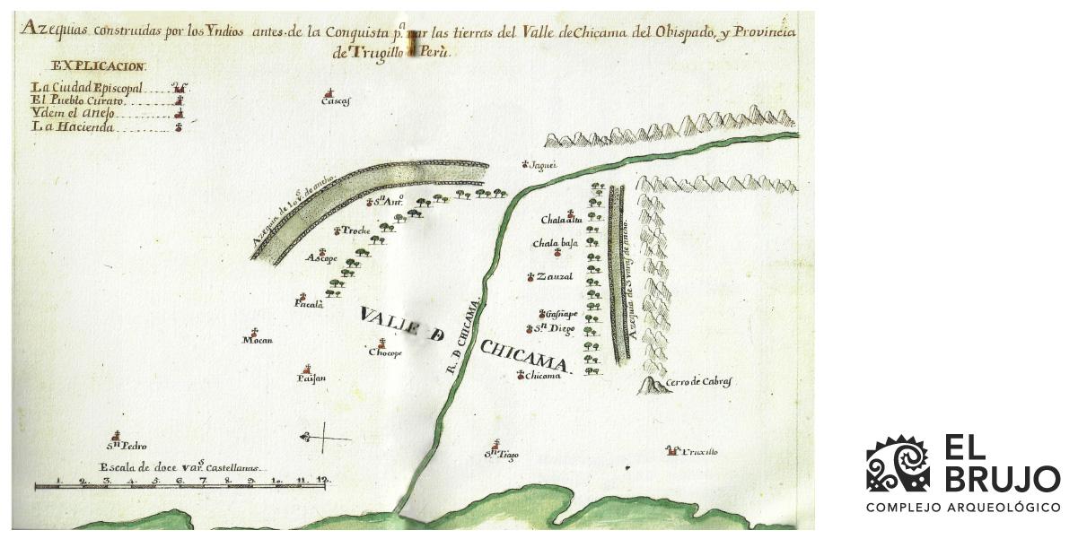
Figure 1. Representation of the canal system of Ascope (left) and the inter-valley Chicama-Moche canal (right). The monumentality and importance of this pre-Hispanic hydraulic system in the Chicama Valley was still notable in the 18th century. Drawing published by Bishop Martínez Compañón (Martínez Compañón 1998, f. 11).
Some Chimú Settlements
The Chimú occupation in the Chicama Valley was not only expressed in the construction of hydraulic projects. To this day, the remains of some Chimú buildings have been occasionally preserved, erected mainly over the old Moche and Lambayeque architecture, with the objective of guaranteeing maximum exploitation of the river’s water and consolidating their domain (Clément 2016; Prieto 2014).
The site of Quebrada del Oso and the late residential sector at the El Brujo Archaeological Complex are the best-preserved expressions of the Chimú presence in the Chicama Valley.

Figure 2. Map of the Chicama Valley with irrigation systems and settlements from the Chimú Period. Map published by Camille Clément (Clément 2016, fig. 2).
Quebrada del Oso (PV23-477)
The site of Quebrada del Oso is located near Chicamita. It displays three well-differentiated sectors, which would have reflected hierarchical relationships among their occupants, with the central building being the most notable as it presents “audiencias”, the typical Chimú architectural form existing at Chan Chan and at its provincial settlements (Keatinge 1974, p. 75). In any case, the general function of the site was aimed at the maintenance of the inter-valley canal and the agricultural exploitation of the gorge (Clément 2016 p. 41; Keatinge 1974 p. 79; Kus 1972 p. 144). Regarding this last point, Kus recorded six types of agricultural fields associated with Quebrada del Oso based on the furrows displayed (see Figure 4). The chronology of the site is discussed by Thomas and Shelia Pozorski. They obtained nine radiocarbon samples from the section of the inter-valley canal directly associated with the settlement of Quebrada del Oso, whose dates are in the range of 1040 to 1310 CE. However, the researchers didn’t detail the types of materials dated or discuss the suitability of the samples (Pozorski & Pozorski 1982, p. 860, 866); therefore, detailed analyses to elucidate the dates of construction for the canal as well as the use of the Quebrada del Oso site remain to be carried out.
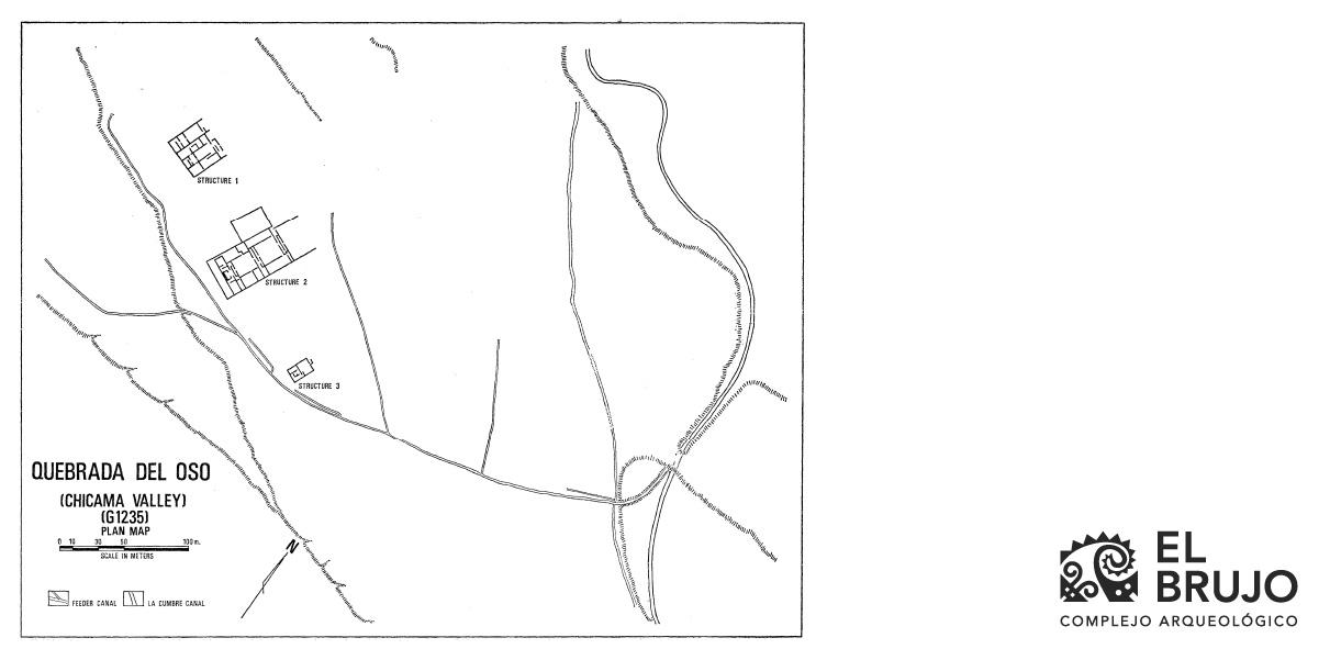
Figure 3. The site of Quebrada del Oso in the Chicama Valley (Keatinge 1974, fig. 22).


Figure 4. The six types of agricultural fields identified by James Kus at the site of Quebrada del Oso (Kus 1972, fig. 2-7).
The Chimú residential sector at the El Brujo Archaeological Complex
The El Brujo Archaeological Complex contains evidence of continuous human occupation starting 14,000 years ago. In this prolific cultural history, the traces of the Chimú presence are expressed in small houses and attached plazas, and are distributed over an extensive area south of Huaca Cortada. Its architectural configuration is similar to that which exists in the residential sectors of the lower-class population at Chan Chan. Nevertheless, the investigations of James Tate have detailed that in this place lived fisherpeople, farmers, artisans, and an elite class that had privileged access to special goods such as Spondylus shell, which retained its importance in the Tahuantinsuyu era (Tate 2006, p. 315-317).
Additional evidence recorded at the El Brujo Archaeological Complex includes funerary structures. In the 1930s, archaeologists Wendell Bennett and Alfred Kroeber identified cemeteries with Chimú ceramics in areas near the complex, but not much remains of them due to intense looting.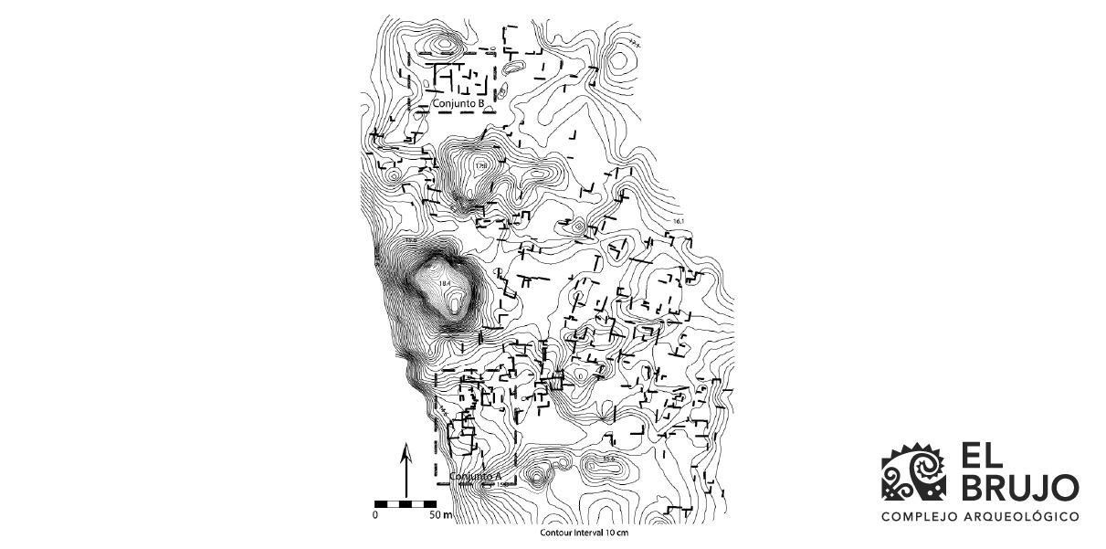
Figure 5. Map of the Chimú residential sector at the El Brujo Archaeological Complex (Tate 2006).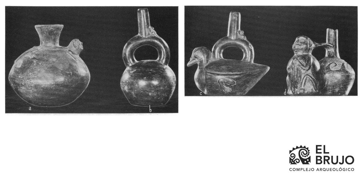
Figure 6. Chimú-style bottles from tombs looted at the El Brujo Archaeological Complex (Bennett 1939, fig. 17).
Final comments
The Chicama Valley was one of the first geographic spaces that the Chimú incorporated into their territorial expansion. Their dominion was based primarily on optimizing agricultural production for their metropolises, for which they expended enormous efforts in planning, the transportation of construction materials, and the mobilization of communities, mostly rural inhabitants, to carry out the construction projects for the irrigation canals and sites dedicated to the maintenance and management of water.
Also, evidence from the Chimú residential sector at El Brujo indicates that, by this time period, there was a defined social hierarchy within the community such as that previously identified at the city of Chan Chan; however, new and comprehensive investigations related to the communities of the valley will allow us to evaluate the extent of these social differences among the pre-Hispanic communities of the Chicama Valley.
Researchers , outstanding news


