- Visitors
- Researchers
- Students
- Community
- Information for the tourist
- Hours and fees
- How to get?
- Visitor Regulations
- Virtual tours
- Classic route
- Mystical route
- Specialized route
- Site museum
- Know the town
- Cultural Spaces
- Cao Museum
- Huaca Cao Viejo
- Huaca Prieta
- Huaca Cortada
- Ceremonial Well
- Walls
- Play at home
- Puzzle
- Trivia
- Memorize
- Crosswords
- Alphabet soup
- Crafts
- Pac-Man Moche
- Workshops and Inventory
- Micro-workshops
- Collections inventory
- News
- Researchers
- The Inca Empire and the Chicama Valley
News
CategoriesSelect the category you want to see:
The 44 Nose Ornaments of the Lady of Cao at El Brujo (La Libertad, Peru): Emblems of Power and Moche Duality ...
Cinnabar: The Mineral That Preserved the Lady of Cao? ...
To receive new news.
By: Jose Ismael Alva Ch
Jose Ismael Alva Ch.
Resident Archaeologist at the El Brujo Archaeological Complex
During the second half of the 15th century, a powerful empire expanded rapidly from the southern highlands of the Andes to the coast. The Incas commanded their armies to subdue the peoples of the lowlands with the objective of accessing a greater force of labor, agricultural products, and the knowledge and goods produced by the most skilled artisans.
In the Chicama Valley, evidence of the Inca Occupation is commonly represented by the archaeological site of Chiquitoy Viejo, an ostentatious administrative settlement. However, there are other tambo-type structures associated with pre-Hispanic roads. Also, investigations have reported archaeological remains that reveal the daily life of coastal peoples during Tahuantinsuyu. In the following text, we will go over the traces of the Incas in this coastal valley together.
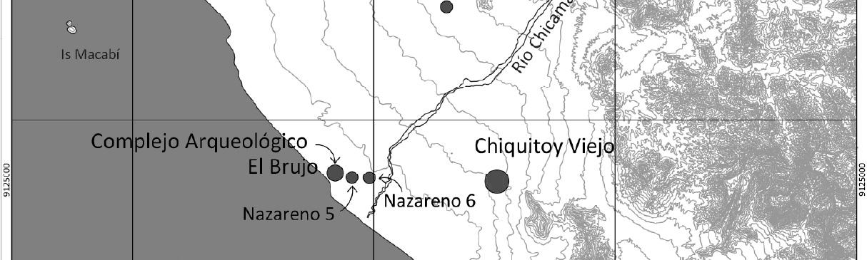
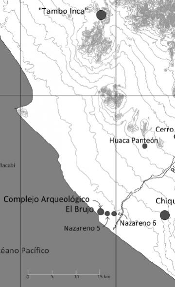
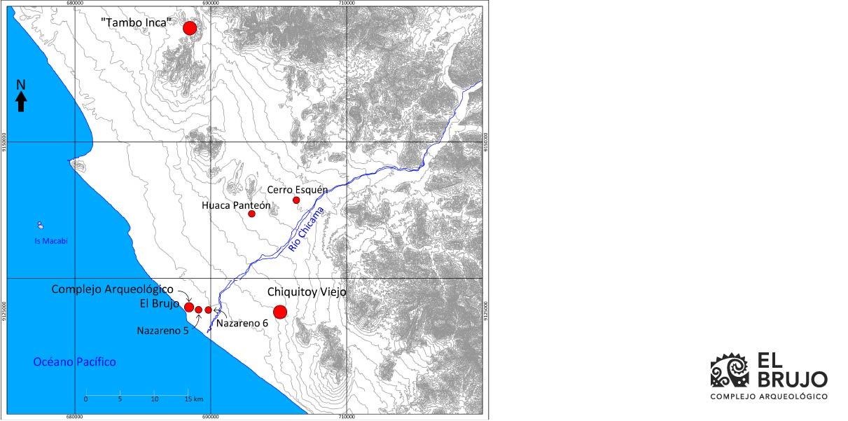 Figure 1. Location of the archaeological sites of the Chicama Valley with Inca remains. Map based on surveys carried out by Claude Chauchat, César Gálvez, and Rosario Becerra.
Inca Tambo (PV22-23)
This archaeological site is comprised of a set of buildings located on a plain on the right-hand shore of the Chicama River. The platforms and structures in the form of a windscreen are made of stone and contain fragments of Chimú-Inca and Inca ceramics, with the remains of Cusqueñan aryballoid vessels standing out.
The explorations of Claude Chauchat in this section of the valley indicate that the structures of this site are associated directly with a road that led to the area of Mocan within the Chicama. Given this connection, Chauchat proposed that this site’s function was that of a tambo, or a place of refuge and provisionment for travelers during Inca times (Chauchat et al. 1998, p. 34).
Chiquitoy Viejo (PV23-481)
This well-known archaeological site is located on the left-hand shore of the Chicama River, specifically on a plain at the southern end of the valley, which was cultivated in antiquity. According to estimates, this site extended for 1 km, but currently its area has diminished due to the expansion of agriculture.
 Figure 2. General map of Chiquitoy Viejo (Conrad 1977, Fig. 3).
The investigations of Geoffrey W. Conrad have allowed us to understand the form and function of Chiquitoy Viejo. A main component of 300 m by 250 m has been identified, which is delimited by walls of up to 8 meters in height. Its interior exhibits large patios, five living spaces, an administrative area, and a funerary platform (Conrad 1977, p. 4-6).
The living areas are distributed around the administrative building and the funerary structure, which occupy a central position. By their characteristics and associated objects, the living areas appear to have corresponded to people who were at the service of the occupants of the administrative area. In difference to the living spaces, the administrative space presents the typical structures in “U” shape, whose function was to serve as the base for indigenous authorities. The funerary platform is adjacent to the administrative area, which is composed of two segments of cells whose contents were altered by looters. Even so, among the remains left behind by the “huaqueros”, luxury goods such as Spondylus shells, exotic bird feathers, carved wood, fine ceramics, decorated textiles, etc., have been identified, indicating that the main figure belonged to the elite (Conrad 1977, p. 6-13).
 Figure 3. Map of the main component of Chiquitoy Viejo (Conrad, 1977, Fig. 4)
Although the architecture of Chiquitoy Viejo obeys the local constructive parameters of the Chimú, the ceramics recovered from the sectors of Chiquitoy show a clear affiliation with the Inca style and its combination with Chimú styles. This indicates that the settlement must have been constructed and occupied by the people of the area to comply with the interests of the Inca Empire (Conrad 1977, p. 14; Mujica 2007, p. 280).
The function of the Inca settlement of Chiquitoy Viejo must be understood through its association with the main road that connected the Chicama Valley with the Moche Valley. From this location, the Inca were able to supervise the trade of high-value goods in the Chimú territory (Conrad 1977, p. 11). This use of the site continued until the beginning of the Colonial Period; it was in this place that the conquistador Francisco Pizarro stayed while he received news from the surrounding valleys (Prieto 2014, p. 11).
The Chimú-Inca Sector of the El Brujo Archaeological Complex (PV23-462)
At the El Brujo Archaeological Complex, to the North of the mouth of the Chicama River, the remains of a Chimú settlement that maintained its function during Inca rule are located. This settlement is characterized by small living areas and attached plazas, very similar to what exists in the residential sectors for the lower-class population at Chan Chan.
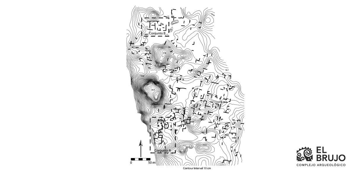 Figure 4. Map of the Chimú residential sector at the El Brujo Archaeological Complex (Tate 2006).
The investigations of James Tate revealed that the human groups that inhabited this sector of El Brujo were fisherpeople, farmers, and artisans. The people of these social sectors went about their daily lives with simple crockery that was functionally associated with the activity of food preparation. It is notable that more than 75% of the ceramic fragments studied by Tate are from pots (Tate 2006, pg. 315-317).
Also, the elite that resided there as well had close relationships with the Inca state. In this manner, the ethnic leaders of El Brujo improved their positions of power and prestige through privileged access to special goods such as Spondylus shells, fine textiles, and Inca ceramics (Tate 2006, p. 207, 315-317, 328).
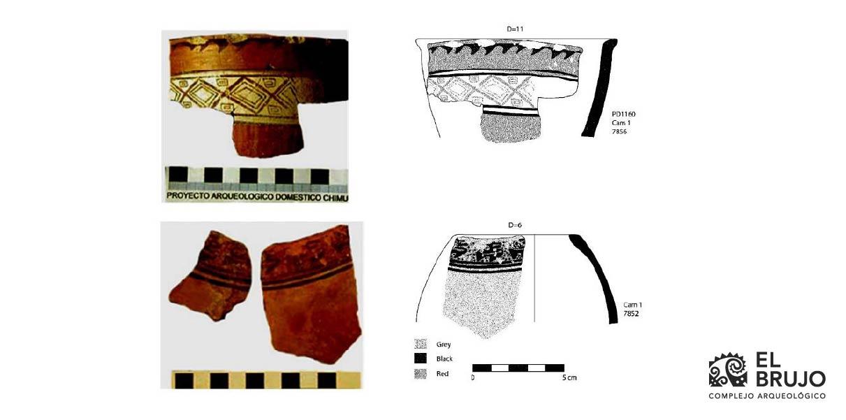 Figure 5. Ceramic fragments from the Inca Period recovered from the elite spaces of the late domestic sector of the El Brujo Archaeological Complex (Tate 2006, p. 249).
To this evidence is added the discovery, on the northern face of Huaca Cao Viejo, of two aryballoid vessels, typical of the Inca presence in the provinces of Tahuantinsuyu, and of Chimú-Inca-style bottles, expressions of the stylistic mixing of the local and the imperial. These pieces came from tombs disturbed by looters, which made it impossible to identify the individuals who possessed these objects as funerary offerings. Despite this, the quality of the vessels indicates that these characters must have belonged to the local elite of the lower Chicama Valley.
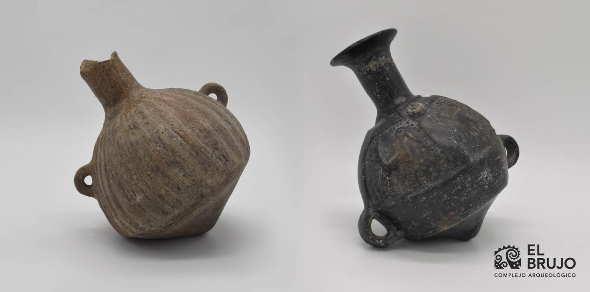 Figure 6. Inca aryballoid vessels produced locally found on the northern face of Huaca Cao Viejo. Left: EBBCE0000-579 (17 cm in height). Right: EBBCE0000-9 (21 cm in height).
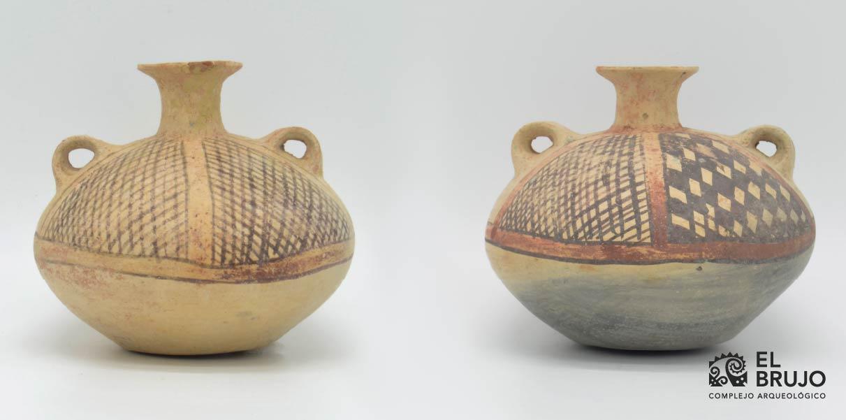
Figure 7. Chimú-Inca-style vessels recovered from the northern face of Huaca Cao Viejo in 1993. Left: EBBCE0000-22 (12.3 cm in height). Right: EBBCE0000-152 (12 cm in height).
Other sites from the Inca Period
Explorations on the right-hand shore of the Chicama River were carried out by Banks Leonard and Glenn Russell in 1992, and later by César Gálvez and Rosario Becerra (2002). Both projects have allowed for the documentation of some architectural structures associated with Inca-style ceramics.
In the lower valley, specifically in the modern district of Chocope, Huaca Panteón and Cerro Esquén are located. Huaca Panteón displays architecture linked to the early Colonial Period; however, the existence of Inca ceramics indicates that its foundations were possibly from the Tawintinsuyu era. At Cerro Esquén, a cemetery was found, whose individuals were buried with Inca ceramics as offerings. Keeping in mind that these imperial vessels had a restricted distribution among the provinces, the individuals buried at Cerro Esquén must have been members of the Chicama elite. (Gálvez & Becerra 2003).
Close to the mouth of the Chicama River, and to the Southeast of the El Brujo Archaeological Complex, the sites named Nazareno 5 and Nazareno 6 are located. Nazareno 5 was affected by heavy machinery and only ceramic materials from the Inca Period could be recorded. In contrast, Nazareno 6 displays larger components that functionally seem similar to the domestic sector of El Brujo, as they present habitational complexes, a cemetery with the remains of Inca ceramics, and natural terraces conditioned for agriculture.
Final comments
The Inca expansion was the last imperial project of a pan-Andean reach. In each valley, however, the Inca expressed their dominance in a different way. This depended on the natural and social characteristics of the region, the specific interests that the Cuzqueñans had, and the negotiation of power that existed between the local elite and the imperials.
In the Chicama Valley, the Inca presence was not expressed through grand Cuzqueñan-style buildings. Their control was periodic and strategic, but followed the administrative patterns developed by the Chimú, something already perceived by Geoffrey W. Conrad (Conrad, 1977, p. 18) Even so, what can be observed from the investigations of James Tate and archaeological surveys is that Inca dominance was carried out through the curacas, or local ethnic leaders, themselves, who sought to maintain their privileges and social position by serving as provincial administrators. New investigations will allow as to clarify and detail these mechanisms of Inca domination in this fertile valley and will surely broaden the constellation of settlements from this period.
Researchers , outstanding news