- Visitors
- Researchers
- Students
- Community
- Information for the tourist
- Hours and fees
- How to get?
- Visitor Regulations
- Virtual tours
- Classic route
- Mystical route
- Specialized route
- Site museum
- Know the town
- Cultural Spaces
- Cao Museum
- Huaca Cao Viejo
- Huaca Prieta
- Huaca Cortada
- Ceremonial Well
- Walls
- Play at home
- Puzzle
- Trivia
- Memorize
- Crosswords
- Alphabet soup
- Crafts
- Pac-Man Moche
- Workshops and Inventory
- Micro-workshops
- Collections inventory
- News
- Researchers
- Apu Campana in the maritime records the XVII to the XIX centuries
News
CategoriesSelect the category you want to see:
The 44 Nose Ornaments of the Lady of Cao at El Brujo (La Libertad, Peru): Emblems of Power and Moche Duality ...
Cinnabar: The Mineral That Preserved the Lady of Cao? ...
To receive new news.
By: José Ismael Alva Chancos
By: José Ismael Alva Chancos
“… I heard on faraway mounts and guacas (as on the mount next to Chocope, and on the one they call Canpana, and on other different ones) loud noises from drums, the musical instrument of the Indians, in a lugubrious, sad and afflicted tone.
(Calancha, 1638, t. IV, Cap. IV).
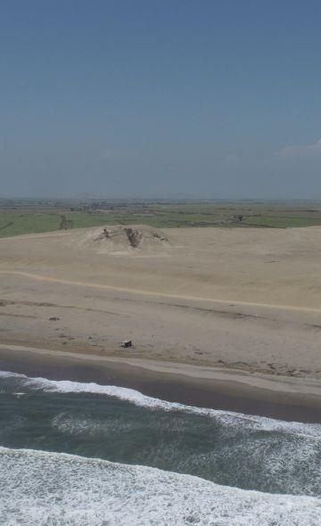
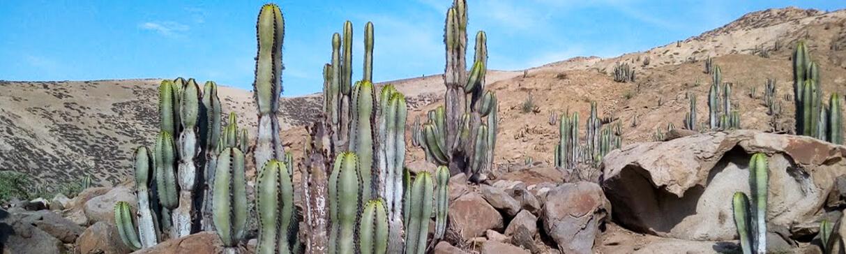
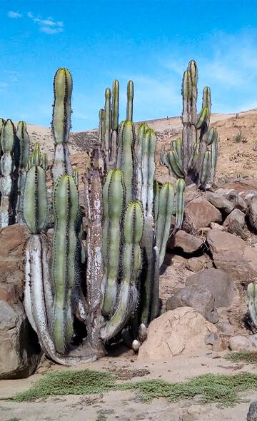
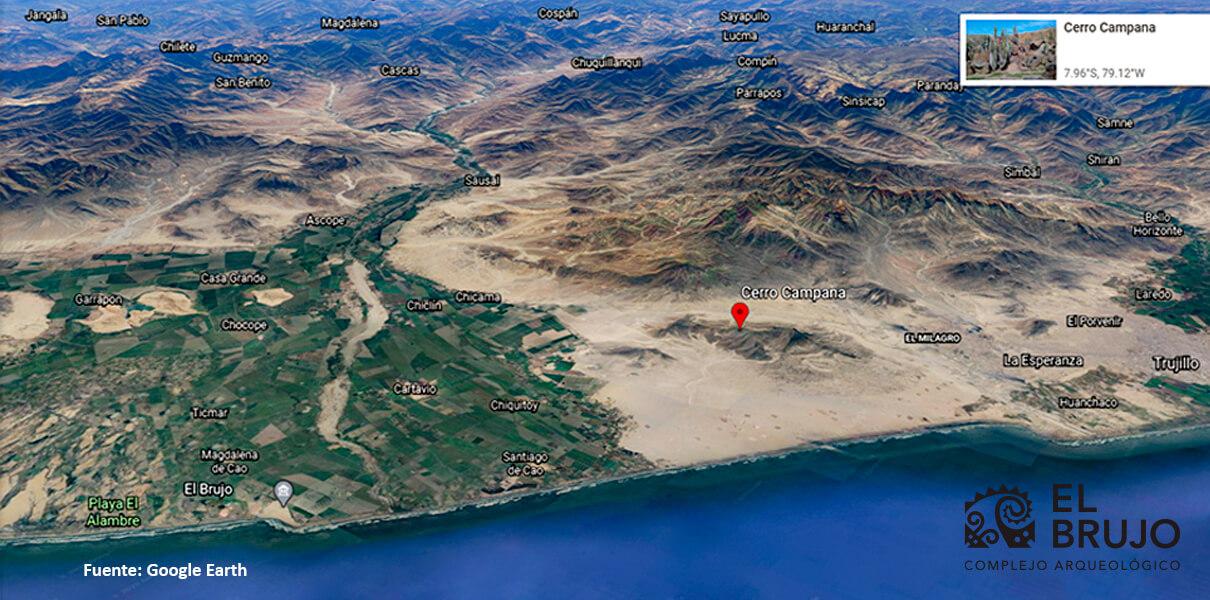
Cerro Campana (Mount Campana in Spanish, or Apu Campana in Quechua) is a notable and steep hill, or mountain, located in the existing deserted plains between the valleys of Moche and Chicama. It reaches an approximate height of 1000 MASL and it extends 9 km from north to south. Although it has a rocky and sterile surface, during the winter months the western slope greens like a mound due to the humidity brought by the winds from the Pacific Ocean. In this season of the year, Cerro Campana reaches the greatest density of flora and fauna.
At the beginning of the XVII century, Father Antonio de la Calancha, in his evangelizing effort, pointed out that on that mount it was possible to hear loud sounds attributed to demons that lamented for not being worshiped by the locals. Said account, with its variants in later centuries, tells of the attention paid to the mount in times of the extirpation of idolatries in the Andes, so it is clear that its sacred nature was assigned in the pre-Hispanic epoch.
The archaeological evidence obtained from Cerro Campana show that the place was used as a quarry for hematite [1] from the Formative period (Prieto et al. 2016). Moreover, its occupation intensified in Moche times with the presence of altars on different spots as one surrounds and climbs the mount (Franco et al. 2013).
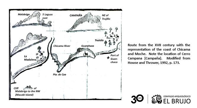
Although there are allusions to Cerro Campana in the works of travelers from the end of the XIX century, such as George Squier (1877) from the United States and Ernst Middendorf (1894) from Germany, on this occasion we are interested in another type of written source, an even older one: the maritime routes of the XVII, XVIII and XIX centuries. These were mostly illustrated documents that contained instructions on the navigation routes, emphasizing on the characteristics of the coastlines, ports, cities and geographic features visible from the sea. In America, Spanish navigators and, later on, republican ones crafted various nautical publications with detailed descriptions of the most important points of reference on the coast, thus guaranteeing their trajectory and avoiding possible hazards along the route.
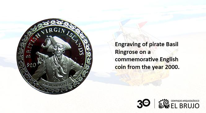
The earliest route to which we had access is that obtained by the English pirate Basil Ringrose after the highjacking of a Spanish ship in Panama. Ringrose navigated along the American coasts in the decade of 1680 to reconnoiter and plunder the colonies of the Spanish Crown during 18 months. The document being mentioned depicts the coastline of the Chicama and Moche valleys, where one can identify the city of Trujillo, the port of Huanchaco and the town of Magdalena de Cao. Furthermore, the location of Cerro Campana (Campaña, in his notes) stands out as a point of reference in the event of having to anchor and disembark at the port of Huanchaco:
“From Malabrigo you navigate SE to the port of Guanchaco, the wharf for the city of Trujillo, which is a diocese and a very good place. The long side of the coast has an iron shore [1]. You must dock at 9 fathoms [2] west of the church, which you will see at the Port o [of Guanchaco] and Cerro Campaña NE of you.” (Howse and Throwear, 1992, pp. 172-174).

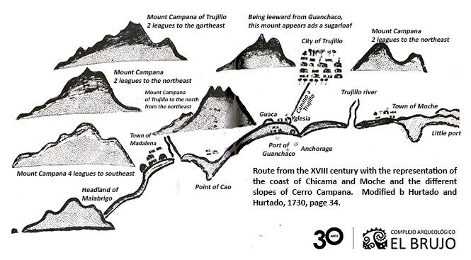
Half a century later, in 1730, royalist captains Pedro Hurtado de Mendoza and Manuel Joseph Hurtado crafted a route that represented the coast of Chicama. That drawing not only showed the location of Cerro Campana that resembled a “sugarloaf” as seen from Huanchaco, but it also depicted its profiles according to the location and distance from its vantage point.
In the republican period, and before the war with Spain, another route was crafted by Lieutenant Aurelio García y García, commander of the Steamship “General Lerzundi” from the Peruvian navy. This document is more detailed compared to the previous routes:
“Cerro Campana is the most notable on all the coast. It is located six miles to the north of the port [of Huanchaco] and 5 miles inland. It owes its name to the shape that it represents, which is like an old bell placed on the ground: it ends in some crests that imitate the handles from which the bell is suspended. Its elevation is of three thousand four hundred fifty feet above sea level: the particular shape that it has and its isolated location make it unmistakable: it can be spotted from a long distance. Very often, one can see its upper part, cut by a band of mist that leaves uncovered the top and the base,” (García and García, 1863, pp. 134-135).
After reviewing these little-known historical sources, we can say that the maritime routes contain a sum of important information linked to preponderant elements on the Andean coast. In them, one can recognize not only the Spanish foundations in America, but also the “huacas” (sanctuaries), mounts, islands and other geographic features that were social referents in the territories of the ancient human groups in pre-colonial times.
In sum, all of the data available reinforce the position of Cerro Campana as one of the outstanding points on the North Coast of Peru. The early evidence of human occupation, the altars and the probable ritual enclosures from the Moche epoch on location show the close relationship of the mount with the ideological discourses and the religious practices in the pre-Hispanic epoch, whose purpose was to renew and maintain the social order. This attribution of cultural meanings though ritual activity, as well as the later legends, turn Cerro Campana into a true landmark in the Andean landscape.
[1] Iron Shore: Rocky and steep coast without anchorage.
[2] A fathom is a nautical measuring unit, employed normally to measure the depth of the sea. In the English measure used by Ringrose, the fathom was equal to 1.8 meters.
[1] Hematite was utilized to obtain red pigment.
Researchers , outstanding news